Supply chain-zichtbaarheid: hoe realtime locatietechnologie de datakloof sluit

Loop door de meeste magazijnen of productieomgevingen en u ziet telkens dezelfde stille frustratie: iemand zoekt iets waarvan het systeem zegt dat het er zou moeten zijn. Een pallet die gisteren werd geregistreerd. Een container die twee dagen geleden bij de leverancier vertrok. Een stuk materieel dat vorige week werd teruggebracht.
De registraties kloppen. Alleen bevindt het asset zich ergens anders.
Dit is de zichtbaarheidskloof, en de omvang ervan is opvallend. Voor organisaties die volledige zichtbaarheid in supply chain-logistiek willen, is dit het voorspelbare gevolg van werken met systemen die zijn ontworpen om beslissingen vast te leggen, niet om fysieke beweging continu te volgen.
Transactiegegevens versus de fysieke realiteit
ERP-, WMS- en TMS-platformen vormen de ruggengraat van modern supply chain management. Maar ze delen een fundamentele beperking: ze worden bijgewerkt wanneer iets wordt geregistreerd, niet wanneer iets beweegt.
Tussen die geregistreerde momenten blijven materialen langer dan verwacht op de productievloer staan. Voorraad wordt verplaatst binnen een magazijn. Containers blijven op partnerlocaties ruim na hun geplande retourdatum staan. Goederen in bewerking blijven hangen tussen productiestappen. Herbruikbare verpakkingen circuleren door leveranciersnetwerken zonder een betrouwbare manier om te weten waar ze zich bevinden of hoe lang ze stilstaan. Geen van die gebeurtenissen genereert een systeemupdate, terwijl ze wel stilaan de nauwkeurigheid ondermijnen van de data waarop operationele teams hun beslissingen baseren.
De kloof tussen wat systemen tonen en wat er fysiek gebeurt, is waar vertragingen ontstaan, assets verdwijnen en kosten oplopen. Meestal onzichtbaar, tot het probleem te groot wordt om te negeren.
Ontdek het Pozyx Platform
Het Pozyx platform brengt positioneringsgegevens samen om volledige zichtbaarheid te geven aan logistiek en productie.
Pozyx PlatformSupply chain-zichtbaarheidstechnologie: van beperking naar convergentie
Volledige supply chain-zichtbaarheid realiseren is nooit alleen een dataprobleem geweest. Het is altijd ook een technologisch vraagstuk geweest.
Lange tijd waren de beschikbare tools simpelweg niet ontworpen om continue, betrouwbare locatiegegevens te leveren in complexe omgevingen. RFID wordt bijvoorbeeld breed ingezet in supply chains, maar omdat het afhankelijk is van vaste checkpoints en manuele of geautomatiseerde scans, bevestigt het alleen waar een asset voor het laatst is gezien, niet waar het zich nu bevindt. Zodra iets buiten die checkpoints beweegt, verdwijnt het uit beeld.
Meer recent werden cellulaire positioneringstechnologieën zoals 5G en in de toekomst 6G naar voren geschoven als mogelijk antwoord, met de belofte van naadloze indoor-outdoor tracking via één netwerk. In de praktijk zijn deze technologieën echter nog volop in ontwikkeling. Zoals toegelicht in Is 5G ready or not for industrial asset tracking?, beperken uitdagingen rond energieverbruik, kost en infrastructuurvereisten hun inzet vooral tot assets met een hogere waarde, zoals voertuigen, AGV’s of handhelds, in plaats van de duizenden goedkopere assets die doorgaans door een supply chain bewegen. ABI Research benadrukt bovendien dat ondernemingen nog altijd aanzienlijke drempels ervaren om RTLS op schaal uit te rollen, waarbij 87% van de organisaties zulke systemen nog niet volledig heeft geïmplementeerd.
Tegelijk zijn andere positioneringstechnologieën sterk geëvolueerd. Bluetooth Low Energy (BLE), Ultra-Wideband (UWB) en GPS zijn elk verder ontwikkeld om specifieke delen van het zichtbaarheidsprobleem effectiever op te lossen.
BLE maakt schaalbare indoor tracking mogelijk in grote sites, met lage infrastructuurkosten en een lange batterijduur, waardoor uitrol over duizenden assets praktisch haalbaar wordt. UWB-tracking levert consistente nauwkeurigheid op centimeterniveau via time-of-flight-positionering, zelfs in complexe industriële omgevingen waar interferentie normaal prestaties zou aantasten. En GPS blijft verbeteren als betrouwbare laag voor outdoor tracking, met innovaties in energie-efficiëntie en hybride positionering die de rol van GPS in asset tracking verbreden tot ver buiten klassieke fleet use cases. (Bekijk voor meer context ook 5 innovations in GPS asset tracking.)
Wat veranderd is, is niet alleen de prestatie van afzonderlijke technologieën, maar ook de mogelijkheid om ze te combineren. Op een hoger niveau standaardiseert de omlox Hub locatiegegevens uit verschillende positioneringssystemen tot één uniforme, technologie-onafhankelijke datalaag. Daardoor wordt het mogelijk om per omgeving de juiste technologie in te zetten (UWB voor precisie, BLE voor schaal, GPS voor outdoor tracking) en toch één consistente kijk te behouden op assetlocatie, beweging en gebeurtenissen over de volledige supply chain.
Samen maken die convergentie van technologieën en die standaardisatie continue, end-to-end supply chain-zichtbaarheid eindelijk haalbaar, van de productievloer tot het logistieke netwerk en weer terug.
Wat verandert er wanneer zichtbaarheid verbetert?
De verschuiving van reactieve supply chain-monitoring naar realtime zichtbaarheid verandert waar operationele teams op kunnen sturen.
De operationele businesscase is goed onderbouwd. Onderzoek van McKinsey naar de volgende generatie supply chain-operaties voorspelt tot 30% lagere operationele kosten, 75% minder gemiste verkopen en voorraadreducties tot 75% voor organisaties die realtime locatiedata benutten. Een recentere analyse van McKinsey toont dat een luchtvaartbedrijf dat zijn werking herstructureerde rond betere supply chain-zichtbaarheid, de kosten voor spoedservices met 30 tot 50% verlaagde en de voorraadomloop met 15 tot 20% verbeterde.
Wanneer teams zien waar assets zich echt bevinden, daalt de zoektijd, komen bottlenecks eerder aan het licht en verlopen assetcycli strakker over het volledige netwerk. Historische bewegingsdata versterkt die waarde in de tijd: u ziet niet alleen waar iets is, maar ook hoe het beweegt, waar het vertraagt en waar processen kunnen verbeteren.
De verschuiving is duidelijk: van sturen op wat werd geregistreerd naar sturen op wat er daadwerkelijk gebeurt.
Lees hoe Pozyx-klanten locatiedata omzetten in meetbare operationele winst. Bekijk de case studies.
Waar Pozyx het verschil maakt
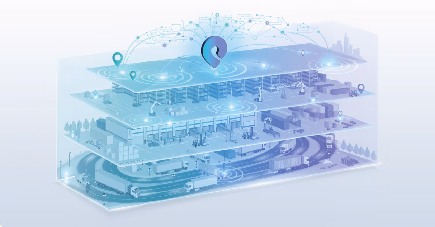
Pozyx bouwt realtime locatiesystemen die specifiek zijn ontworpen voor de indoor-outdoor zichtbaarheidskloof. Het platform brengt UWB, BLE en GPS samen in één uniform overzicht, zodat organisaties assets continu kunnen volgen, ongeacht waar ze zich in de supply chain bevinden.
Binnen een site levert Pozyx zichtbaarheid in productie met de precisie die locatiedata echt bruikbaar maakt voor operationele besluitvorming. UWB wordt ingezet waar exacte positionering cruciaal is en geeft productiemanagers een live beeld van waar een component zich precies bevindt, of een tool naar de juiste werkpost is teruggekeerd en hoe lang een pallet al in een staging zone staat. BLE breidt die dekking uit naar grotere zones waar zonegebaseerd inzicht volstaat, zonder dezelfde infrastructuurdichtheid te vereisen. Samen zorgen ze ervoor dat niets binnen een site uit beeld verdwijnt.
Buiten neemt GPS het over. Voertuigen en containers die tussen sites bewegen, worden continu gevolgd, waarbij locatiegegevens binnenstromen in hetzelfde platform dat ook indoor positionering beheert. Maar de functionaliteit stopt niet aan de poort van de site. GPS-devices van Pozyx kunnen ook BLE-signalen van getagde assets scannen. Daardoor weet het systeem, wanneer een getagde container of pallet op een gevolgd voertuig wordt geladen, welke assets zich op welke truck bevinden en waar die truck zich tijdens het transport bevindt. Een asset verdwijnt dus niet zodra het het gebouw verlaat, maar blijft zichtbaar tijdens de volledige rit, van de productievloer tot levering en terug.
Al die data komt samen in het Pozyx-platform, dat operationele teams één centrale plek geeft om elk gevolgd asset in hun netwerk te bekijken. Live vloerkaarten tonen assetposities in realtime, terwijl rapporteringstools teams laten inzoomen op bewegingshistoriek, dwell times en gebruikspatronen. Analytics boven op die data maken het eenvoudig om terugkerende bottlenecks te detecteren, assetbeschikbaarheid in de tijd op te volgen en een operationeel beeld op te bouwen dat betere planning ondersteunt. In plaats van informatie uit meerdere losstaande systemen samen te brengen, krijgen teams end-to-end supply chain-zichtbaarheid, één helder beeld van wat er gebeurt en de tools om erop te handelen.
Het platform is gebouwd rond de omlox Hub, die locatiegegevens uit verschillende technologieën en devices standaardiseert tot één consistente datalaag. Daardoor kunnen geofencing, assetbewegingen en events op een uniforme manier worden toegepast, ongeacht of de data afkomstig is van UWB, BLE of GPS. Via gestandaardiseerde API’s maakt de omlox Hub standaardkoppelingen mogelijk met grote ERP- en WMS-systemen, waaronder SAP en Oracle, zodat realtime locatiedata rechtstreeks terechtkomt in de tools waarop operationele teams vandaag al vertrouwen.
De kern van de zaak
De meeste supply chains worden vandaag beheerd op basis van een beeld van de realiteit dat al verouderd is tegen de tijd dat het op een dashboard verschijnt. In die kloof lekken efficiëntie weg, verdwijnen assets en worden beslissingen genomen op basis van onvolledige informatie.
Die kloof dichten vraagt niet om bestaande infrastructuur te vervangen. Het vraagt om de fysieke laag toe te voegen die in die systemen ontbreekt. Organisaties die dat doen, stoppen met reageren op problemen die al zijn geëscaleerd en beginnen hun operaties te sturen zoals ze zich werkelijk ontvouwen.
Krijg volledige supply chain-zichtbaarheid met de realtime locatieoplossingen van Pozyx en ontdek hoe uw operaties efficiënter kunnen draaien.
Geschreven door
Benjamin Smith, MBA

Marketingspecialist bij Pozyx
Ben combineert een achtergrond in bedrijfsontwikkeling en marktonderzoek met een sterke interesse in industriële technologie en locatie-informatie. Hij is gepassioneerd om te onderzoeken hoe innovatieve trackingtechnologieën de efficiëntie, zichtbaarheid en besluitvorming in verschillende sectoren kunnen verbeteren.