
Gestion de flotte AMR et AGV : pourquoi le RTLS

Dans les environnements automatisés, RTLS est utile car il aide à localiser les articles et les actifs dans l’ensemble de l’installation, et tout le monde sait où se trouvent tout et tout le monde, et… c’est l’idée de base. Bien que tout cela soit vrai et utile, il manque quelque chose. Le RTLS s’attaque fondamentalement à des problèmes que l’on ne connaît pas forcément ou qui ne sont pas visibles depuis un tableau de bord de reporting.
Pour les chariots élévateurs, le RTLS se concentre sur l’analyse comportementale et la responsabilisation humaine. Nous explorons ce sujet plus en détail dans notre article sur le suivi des chariots élévateurs→.
Les problèmes liés aux AGV et aux AMR sont beaucoup moins évidents que d’autres. Ils se cachent dans les détails des opérations. Ces deux véhicules ont une idée de leur propre position dans une installation, donc ce n’est pas le problème. Le problème, c’est qu’ils ne connaissent pas l’ensemble du tableau, la vérité, de l’installation qu’ils parcourent. Le RTLS corrige cela en comblant les lacunes de connaissance que ces véhicules ne pourraient autrement jamais combler.
La mauvaise façon de penser le RTLS pour les flottes automatisées
Imaginez un sol d’entrepôt. Des étagères empilées de cartons. Un chariot élévateur dans un coin. Un opérateur qui se déplace entre les rayonnages. Un robot mobile autonome navigue à proximité.
Dans une version, l’opérateur a des points d’interrogation au-dessus de la tête. Il cherche étagère par étagère sans aucun système pour le guider. L’AGV termine sa boucle dans les temps, du moins en apparence. L’AMR navigue avec assurance. Et pourtant, le débit ralentit, une zone de préparation est engorgée, et personne ne parvient à en identifier la cause.
Dans l’autre version, le RTLS Pozyx fonctionne dans toute l’installation. L’opérateur est identifié et localisé. La position réelle de l’AGV est comparée en temps réel à sa position attendue. La position déclarée par l’AMR est recoupée avec une vérité terrain indépendante. Lorsque la réalité s’écarte du plan, le système le sait immédiatement, et non à la fin du poste, quand quelqu’un remarque que les chiffres ne concordent pas.
| ✕ SANS RTLS | ✓ AVEC LE RTLS POZYX |
|---|---|
✕ Les opérateurs cherchent manuellement, aucune visibilité sur les actifs |
✓ Chaque opérateur, véhicule et actif est suivi en direct |
✕ Les retards des AGV restent invisibles jusqu’à la revue de poste |
✓ L’écart de l’AGV par rapport au plan est visible en temps réel |
✕ AMR fonctionnant sur une carte interne obsolète |
✓ Position de l’AMR validée par une vérité terrain indépendante |
✕ Les défaillances de coordination ne sont détectées qu’après coup |
✓ Les conflits sont évités avant même que le LiDAR ne les détecte |
La différence n’est pas que les actifs peuvent se voir entre eux. C’est que l’installation dispose désormais d’une source de vérité indépendante qu’aucun système embarqué de véhicule ne peut fournir.
Découvrez la plateforme Pozyx
La plateforme Pozyx regroupe les données de positionnement intérieures et extérieures pour fournir une visibilité complète des actifs et des enseignements basées sur la localisation au bénéfice de la logistique et la fabrication. Il facilite le contrôle des entrepôts et des stocks, assure le suivi des emballages et des commandes retournables et réduit les coûts liés à la perte d'actifs.
Plateforme Pozyx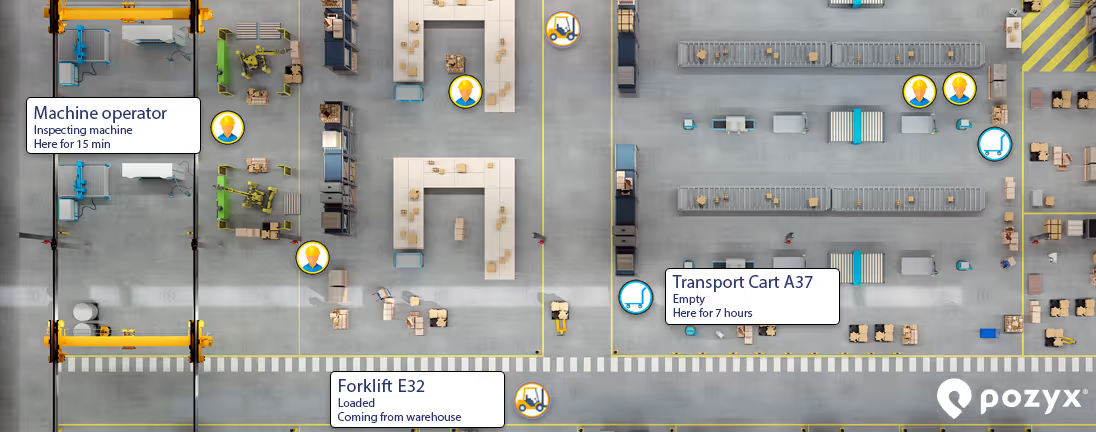
AGV : le problème, c’est une fragilité invisible
Les AGV suivent des trajets fixes à l’aide de bandes magnétiques, de repères au sol ou de réflecteurs laser. Comme le trajet est prédéterminé, leur position relève presque de la formalité. On sait à peu près où un AGV devrait se trouver en fonction de la route qu’il suit et du temps écoulé depuis son départ.
C’est précisément ce qui rend les flottes d’AGV discrètement fragiles, d’une manière difficile à détecter sans RTLS.
Le vrai problème n’est pas de savoir où se trouve l’AGV. C’est de ne pas savoir quand la réalité s’est écartée du plan.
Un AGV censé boucler un trajet en quatre minutes et qui met sept minutes a heurté quelque chose. Un obstacle. Un conflit de circulation avec un chariot élévateur manuel qui s’est engagé sur la voie. Un ralentissement mécanique se transforme en panne. La localisation propre à l’AGV vous dira qu’il est au point de contrôle 4 sur 12. Elle ne vous dira pas qu’il a trois minutes de retard, que ce décalage est sur le point de provoquer une file d’attente à la station de prélèvement, ou que c’est la troisième fois que cela se produit le mardi après-midi lorsqu’un certain schéma de livraison encombre l’allée 7.
Le RTLS vous fournit des données de position continues, indépendantes de la logique de trajet propre à l’AGV, ce qui signifie que vous pouvez suivre en permanence l’écart entre l’endroit où se trouve l’AGV et l’endroit où il devrait être. C’est dans cet écart que se trouve l’intelligence opérationnelle. C’est ce qui vous permet d’anticiper un retard en cascade avant qu’il ne devienne un SLA non respecté, d’identifier les conflits de trajet qui n’apparaissent que dans certaines conditions de circulation, et de construire une reconnaissance historique des schémas qui rend possible une intervention prédictive.
Pour les AGV compatibles VDA5050, la plateforme Pozyx ingère directement leur flux de position via MQTT et le compare au comportement attendu du trajet. Pour ceux qui ne le sont pas, une étiquette UWB sur le véhicule fournit le même flux de position continu, sans dépendance au protocole. Dans tous les cas, la valeur ne réside pas dans la localisation elle-même, mais dans la détection des écarts que permet la localisation continue.
Pour aller plus loin sur l’interopérabilité de VDA5050 et d’omlox en pratique, y compris l’architecture des protocoles et ce que cela signifie pour les déploiements multi-fournisseurs, lisez notre analyse complète →
AMR : le problème, c’est que la carte du robot devient obsolète
Les AMR sont les véhicules les plus sophistiqués sur le terrain. Ils utilisent le LiDAR, des caméras et des capteurs ultrasoniques pour construire et maintenir leur propre carte interne de l’environnement grâce au SLAM, Simultaneous Localization and Mapping. Leur position déclarée est souvent très précise par rapport à cette carte. Alors pourquoi le RTLS est-il important ?
Parce que la carte à laquelle l’AMR se fie ne reste pas exacte.
Les environnements physiques changent en permanence. Une palette est déplacée vers une zone de préparation temporaire. Un nouveau rayonnage est ajouté lors d’une réorganisation le week-end. Une barrière de maintenance est installée en plein poste. Un lot de marchandises entrantes est stationné dans une allée qui était dégagée à 6 h du matin. La carte basée sur le SLAM de l’AMR était exacte au moment de sa création, mais elle se dégrade en temps réel à mesure que la réalité physique autour d’elle évolue. Le robot peut indiquer une position parfaitement exacte par rapport à son propre modèle interne, alors que ce modèle ne reflète plus ce qui se trouve réellement sur le terrain.
Cela crée deux modes de défaillance spécifiques, difficiles à détecter à partir des seules données de l’AMR.
- Dérive de position dans les environnements dynamiques. À mesure que l’AMR se recale sur une carte dont les repères sont obsolètes, de petites erreurs s’accumulent. Le robot pense être à un endroit, mais la réalité physique est légèrement différente. Dans un environnement peu dense, cela a peu d’importance. Dans une installation à forte densité, avec des dégagements étroits, des AGV sur des trajets fixes et des opérateurs partageant les mêmes allées, ce léger écart est précisément ce qui provoque collisions et quasi-accidents.
- Le LiDAR est réactif, tandis que le RTLS est prédictif. Le LiDAR de l’AMR détecte bel et bien les obstacles dynamiques ; c’est l’une de ses fonctions principales. Mais il les détecte dans sa portée de capteur, généralement à quelques mètres, moment auquel le robot réagit : il ralentit, s’arrête ou change d’itinéraire. Un opérateur qui s’approche de l’AMR à 30 mètres en passant par une intersection aveugle n’existe pas pour les capteurs du robot tant qu’il n’est pas assez proche pour être détecté. Aux vitesses opérationnelles, c’est un système réactif qui fonctionne à la limite de sa marge.
Le RTLS sait que l’opérateur se trouve à 30 mètres et se rapproche avant même que l’AMR ne dispose de la moindre donnée de capteur à son sujet. Ce temps d’avance permet au contrôleur de flotte de rediriger le robot ou de le maintenir à un point de passage avant qu’un conflit ne se développe, et non après que le LiDAR a déjà déclenché un arrêt d’urgence. Un arrêt d’urgence parce que le LiDAR a détecté quelqu’un à 3 mètres est un échec de coordination qui a eu la chance d’être intercepté en toute sécurité. Le RTLS empêche que cet échec de coordination ne se produise dès le départ. La distinction n’est pas entre détection et absence de détection ; c’est la différence entre une installation qui réagit aux conflits et une autre qui les empêche.
Pour les AMR, il ne s’agit pas de localiser le robot. Le robot se localise lui-même. Le RTLS fournit une vérité terrain indépendante qui n’hérite pas des angles morts perceptifs de l’AMR, une référence qui existe en dehors du propre modèle du monde du robot, et par rapport à laquelle ce modèle peut être validé et corrigé.
En pratique, sur la plateforme Pozyx, les données de position des AMR issues de VDA5050 sont ingérées et fusionnées dans la couche de localisation unifiée Omlox, aux côtés des données UWB de toutes les autres catégories d’actifs. Cela signifie que le système peut signaler lorsqu’une position déclarée par un AMR s’écarte de manière significative de la vérité terrain ancrée par l’UWB, un signal indiquant qu’une dérive SLAM se produit, que la carte interne du robot doit peut-être être mise à jour, ou qu’un changement environnemental s’est produit et n’a pas encore été traité par le robot.
Ce que la visibilité complète de l’installation permet réellement
Avec le RTLS déployé simultanément sur les AMR, les AGV, les véhicules manuels et les opérateurs équipés d’étiquettes, plusieurs choses deviennent possibles, ce qui n’était pas le cas auparavant.
- Détection des écarts
La position réelle de chaque AGV est comparée en continu au comportement attendu de son trajet. Les retards, blocages et conflits apparaissent en temps réel, et non dans le prochain rapport de poste.
- Vérité terrain indépendante pour les AMR
La plateforme Pozyx fournit une référence de position qui existe en dehors du modèle SLAM de n’importe quel robot, permettant une validation croisée et une détection précoce de la dérive de carte avant qu’elle ne provoque des problèmes opérationnels.
- Conscience dynamique des actifs
Les opérateurs équipés d’étiquettes, les chariots élévateurs manuels et les trains tracteurs apparaissent dans la même couche de localisation que les véhicules automatisés, donnant aux AMR et aux contrôleurs de flotte un contexte sur les obstacles dynamiques que les capteurs embarqués seuls ne peuvent pas fournir avant qu’il ne soit presque trop tard.
- Intelligence des schémas de circulation
Les cartes thermiques construites à partir du suivi continu de plusieurs actifs révèlent les schémas d’interaction entre le trafic automatisé et manuel qu’aucune donnée d’un seul véhicule ne pourrait exposer, l’allée précise, la plage horaire précise et la combinaison précise de types de véhicules qui crée un goulot d’étranglement récurrent.
- Application de la sécurité avec un contexte réel
Les alertes de proximité qui se déclenchent lorsqu’un AMR s’approche d’un opérateur équipé d’une étiquette ne sont pas de simples avertissements basés sur la distance. Avec une visibilité complète de l’installation, le système comprend si cet opérateur est censé être là, si l’AMR dispose d’un itinéraire alternatif et si un ralentissement ou un arrêt est la bonne réponse.
La précision avec les robots autonomes
La phrase qui conclut la propre vidéo produit de Pozyx résume bien la situation : la précision avec les robots autonomes. Pas des données de localisation. La précision, celle qui vient du fait de disposer d’une référence indépendante, à l’échelle de l’installation, qu’aucun système embarqué de robot ne peut produire lui-même.
La logique de trajet de votre AGV vous dit où il devrait être. Le RTLS vous dit quand ce n’est pas le cas. Le modèle SLAM de votre AMR lui dit où il se trouve. Le RTLS vous dit quand ce modèle s’est éloigné de la réalité.
C’est un argument différent, et plus solide, que « tout peut voir tout le monde sur une carte ». C’est l’argument du RTLS comme couche d’intelligence fondamentale qui rend l’automatisation à grande échelle et en flotte mixte gérable, et pas seulement visible.
Le RTLS ne donne pas à vos véhicules automatisés une localisation qu’ils n’ont pas. Il leur donne, ainsi qu’à vous, une source de vérité que leurs propres systèmes sont structurellement incapables de produire.
Prêt à voir à quoi ressemble concrètement une visibilité complète de l’installation ? Pozyx prend en charge VDA5050, omlox, UWB, BLE et GPS : une seule plateforme pour tous les actifs de votre site. Réservez une démo dès aujourd’hui.
Rédigé par
Benjamin Smith, MBA

Spécialiste Marketing chez Pozyx
Ben combine une expérience en développement commercial et en étude de marché avec un fort intérêt pour la technologie industrielle et l'intelligence de localisation. Il est passionné par l'exploration des façons dont les technologies de suivi innovantes peuvent améliorer l'efficacité, la visibilité et la prise de décision dans divers secteurs.