Pozyx GPS
Asset Tracking
Reliable GPS Asset Tracking for Complete Visibility
GPS asset tracking gives you real-time visibility of equipment, shipments, vehicles, and returnable packaging as they move across your operations and supply chain. With compact battery-powered trackers and a powerful central platform, you can monitor asset locations, prevent losses, improve utilization, and streamline logistics. Whether your assets are on the road, at a job site, or in storage, GPS tracking helps you make smarter, faster decisions based on reliable location data.
How Does GPS Asset Tracking Work?
Battery-powered GPS asset trackers determine their position using satellite signals and transmit location data over the cellular network (using NB-IOT or Cat-M1) to a central tracking platform for real-time visibility. To improve accuracy in environments where GPS coverage is limited, some advanced devices also leverage Wi-Fi access point scanning and Bluetooth Low Energy (BLE), enabling reliable location tracking indoors and in areas with poor satellite reception.
To help you plan and optimize your deployments even further, try our Battery Life Calculator; a free online tool that estimates runtime for Pozyx supported GPS and UWB trackers based on your configuration choices.
Top Applications of GPS Asset Tracking
Logistics & Supply Chain Visibility
Battery-powered GPS trackers monitor containers, pallets, trailers, and other mobile assets across warehouses, ports, and transport routes, providing real-time location data and geofencing alerts.
Construction, Equipment & Fleet Management
They help track heavy equipment, tools, and unpowered vehicles on large sites—improving utilization, preventing theft, and enabling quick recovery.
Manufacturing, Industrial & Outdoor Operations
GPS trackers give manufacturers and industrial operators real-time visibility of shipments, work-in-progress, outdoor assets, and returnable packaging moving between facilities.
Cold Chain, Pharma & High-Value Goods
In temperature-sensitive and high-value logistics, GPS trackers secure goods in transit by combining location tracking with sensor data for temperature, shock, and tamper alerts.
GPS Asset Tracking with Pozyx
Pozyx provides a complete, end-to-end solution for GPS asset tracking, delivering all the essential components — from hardware to software — for reliable outdoor tracking. The GPS tracking seamlessly integrates with the Pozyx RTLS for indoor positioning, creating a unified system that provides full asset visibility across indoor and outdoor environments.
1. Real-time GPS Asset Visibility with the Pozyx Platform
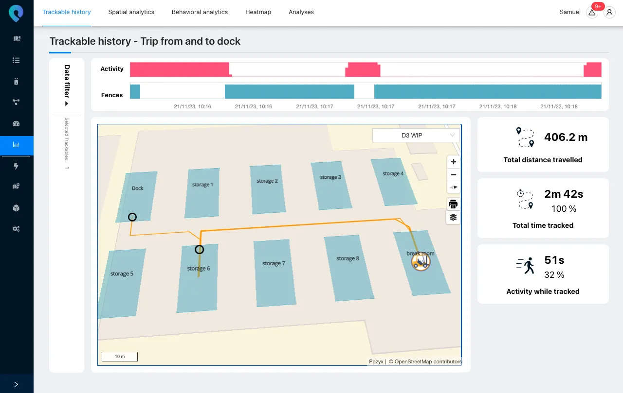
The Pozyx Platform provides complete visibility into the location, movement, and status of your indoor and outdoor assets. Whether you’re tracking returnable containers, tools, vehicles, or rental equipment, the system delivers real-time location updates, movement history, and condition alerts in one unified dashboard. You always know where your assets are, how they’re being used, and when they require attention. Available on desktop and mobile phone.

The asset map with assets and sites
2. Actionable Analytics and Smart Automation
Beyond simple location tracking, the platform offers powerful analytics and automation tools. You can monitor asset utilization, dwell times, and route efficiency through detailed dashboards and reports. Built-in geofencing allows you to create zones that trigger automated alerts or system events when assets enter or leave defined areas. All data is logged and accessible for compliance, optimization, or integration with ERP and WMS systems.
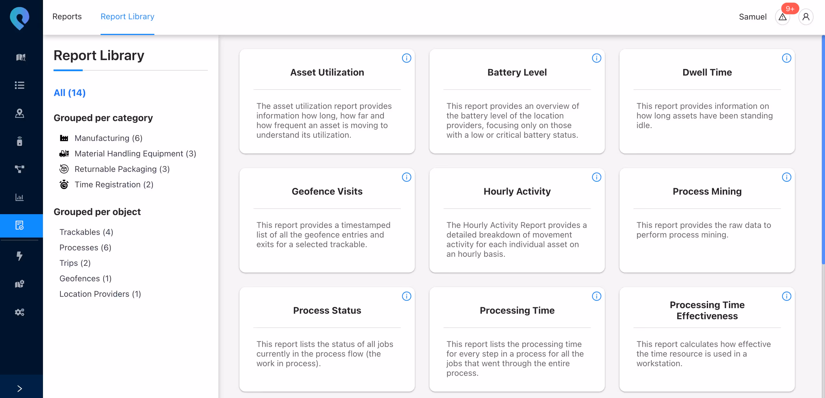
The Report Library in the Pozyx Platform
3. Indoor Positioning with GPS Asset Trackers
While GPS is ideal for outdoor positioning, its signals cannot penetrate buildings. As a result, traditional GPS trackers stop updating once they move indoors, creating visibility gaps in critical operations.
Various ways to deploy a GPS asset tracking system with Pozyx
Pozyx solves this challenge with two complementary solutions that extend GPS tracker visibility into indoor environments:
- Wi-Fi or Bluetooth Scanning for Indoor Approximation.
When GPS signals are unavailable, compatible trackers can scan for nearby Wi-Fi access points or Bluetooth beacons. By identifying the unique MAC addresses of visible networks, an approximate indoor location can be estimated based on known access point or beacon locations. This technique is lightweight, battery-efficient, and especially useful in warehouses, distribution centers, and production facilities with existing Wi-Fi infrastructure. - Using Bluetooth Infrastructure:
For higher accuracy and real-time performance, Pozyx offers BLE-based indoor positioning using its RTLS infrastructure. When a GPS tracker supports Bluetooth broadcasting, the Pozyx anchors can automatically detect these signals and calculate the tracker's position. Depending on the setup, the system provides an indoor location accuracy of 5 to 10 meters. No manual reconfiguration is needed. Everything works automatically within the same platform. This effectively transforms the GPS tracker into a hybrid device, enabling seamless transitions between outdoor GPS and indoor BLE positioning without any loss of data or visibility.
With Pozyx, GPS tracking doesn't stop at the door. Our hybrid approach ensures you maintain end-to-end visibility, whether your assets are outdoors, indoors, or constantly moving between both.
Not sure which approach is best for your use-case? Contact our experts for help!
Available GPS Trackers
Pozyx supports a wide selection of GPS trackers that integrate directly into the Pozyx Platform. These devices are designed for reliable asset tracking in outdoor and hybrid environments, and have been validated for industrial use. We work with trusted partners such as Digital Matter and Teltonika to provide high-quality, field-proven devices that meet diverse operational needs.
Our experts help you identify the most suitable tracker for your project, taking into account your assets, environment, and connectivity requirements.
- Multi-year battery life: Trackers can run for several years on standard replaceable batteries, allowing long-term deployments with minimal maintenance.
- Rugged and waterproof design: Devices are built to withstand demanding industrial environments and are protected against dust, water, and impact (IP68 and IK07 rated).
- Global cellular connectivity: Supports NB-IoT and LTE-M (CAT-M1), with fallback options for 2G, 3G, or 4G. This ensures flexible and low-power connectivity across regions.
- Smart tracking logic: Devices adjust their reporting frequency based on movement, balancing data detail with battery efficiency.
- Tamper detection and recovery mode: Sensors detect unauthorized movement or removal. Devices can automatically switch to a higher reporting rate in case of a security event.
Whether you are tracking containers, tools, vehicles, or mobile equipment, Pozyx ensures that every GPS tracker is selected and configured to support your business goals.
Need assistance?
Our team is ready to guide you through hardware selection, setup, and integration.
Conclusion
Pozyx transforms traditional GPS asset tracking into a powerful, unified solution that delivers full visibility — both outdoors and indoors. With reliable hardware, flexible connectivity, and a platform designed for real-time insights and automation, Pozyx ensures your assets are always accounted for, no matter where they are. Whether you're managing containers, tools, or equipment across complex operations, Pozyx helps you track, optimize, and protect what matters most.
in action